|
|
Week #15 Part I, 11-14.December, 2005
|
Angola, LA to New Orleans, LA: Mississippi River Mile 305 to Mile 93 |
|
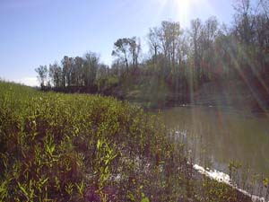 The state of Louisiana brought with it many bayous like the one pictured to the left. A bayou is the remnant of where the river once flowed in the past. As the river finds a new place to meander, the old channels fill in with calm water and offer a peaceful change from the fast pace of the main river. This particular bayou was called Bayou Sara and was located near to the town of St. Francisville, LA. Bayou Sara used to be a bustling port town itself, but was wiped out during one of the flood stages of the Mississippi River and was never rebuilt. As we approached the city of Baton Rouge, we spent another night in a place called Bayou Baton Rouge and awoke before dawn to the greetings of some fisherman who had come to cast their nets for Crawfish bait. Apparently we weren't the only ones who had use for the bayous! The state of Louisiana brought with it many bayous like the one pictured to the left. A bayou is the remnant of where the river once flowed in the past. As the river finds a new place to meander, the old channels fill in with calm water and offer a peaceful change from the fast pace of the main river. This particular bayou was called Bayou Sara and was located near to the town of St. Francisville, LA. Bayou Sara used to be a bustling port town itself, but was wiped out during one of the flood stages of the Mississippi River and was never rebuilt. As we approached the city of Baton Rouge, we spent another night in a place called Bayou Baton Rouge and awoke before dawn to the greetings of some fisherman who had come to cast their nets for Crawfish bait. Apparently we weren't the only ones who had use for the bayous!
|
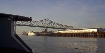 We got an early start on Tuesday as we headed back out on the river, headed for our final stretch on the Mississippi. The photo to the right shows our approach to the port of Baton Rouge. Beyond Baton Rouge the channel is deep enough and the bridges are high enough for ocean-going vessels to navigate the river. Up until this point all we had to worry about in the means of river traffic were the often-gigantic arrays of barges and towboats. But from here on out, we could expect to encounter ocean going vessels hundreds, if not thousands of times bigger than anything we had seen thus far! It makes the BPV Libelula live up to her name, an insect of a vessel, not more than 18 feet long, skimming about in 1.5 feet of water amidst giants. We got an early start on Tuesday as we headed back out on the river, headed for our final stretch on the Mississippi. The photo to the right shows our approach to the port of Baton Rouge. Beyond Baton Rouge the channel is deep enough and the bridges are high enough for ocean-going vessels to navigate the river. Up until this point all we had to worry about in the means of river traffic were the often-gigantic arrays of barges and towboats. But from here on out, we could expect to encounter ocean going vessels hundreds, if not thousands of times bigger than anything we had seen thus far! It makes the BPV Libelula live up to her name, an insect of a vessel, not more than 18 feet long, skimming about in 1.5 feet of water amidst giants.
|
 The
stretch of river from Baton Rouge to New Orleans is long, industrial, and not very kind to small vessels. We were looking at about a 140 mile stretch of open river between the two cities. By this point, we were using the motor quite a bit because of the need to maintain complete control of the vessel at all times due the amount of river traffic we'd be encountering. On our best day with the motor in ideal conditions we had been able to do about 70 miles in a single day. To get from Baton Rouge to New Orleans, we'd have to go as far as we had ever gone in a single day for two days in a row. To make things even more interesting, there was really no place for a small vessel like us to stop on that stretch of the river. There are all sorts of places to tie up for grain vessels heading to China, or Oil Tankers wanting to offload their black gold, but no established points of shelter for small vessels like ourselves. There aren't even any bayous, inlets or islands to pull off into because this is a major shipping channel that is confined on each side of the river by high earthen levees. We were fortunate to have made contact with a facility by the name of Weber Marine that sometimes allows transient pleasure craft to spend the night at their facility. We had called ahead in advance and were told that they would be able to find a place for us to spend the night; and most conveniently, they were located almost exactly between the two metropolis areas! The
stretch of river from Baton Rouge to New Orleans is long, industrial, and not very kind to small vessels. We were looking at about a 140 mile stretch of open river between the two cities. By this point, we were using the motor quite a bit because of the need to maintain complete control of the vessel at all times due the amount of river traffic we'd be encountering. On our best day with the motor in ideal conditions we had been able to do about 70 miles in a single day. To get from Baton Rouge to New Orleans, we'd have to go as far as we had ever gone in a single day for two days in a row. To make things even more interesting, there was really no place for a small vessel like us to stop on that stretch of the river. There are all sorts of places to tie up for grain vessels heading to China, or Oil Tankers wanting to offload their black gold, but no established points of shelter for small vessels like ourselves. There aren't even any bayous, inlets or islands to pull off into because this is a major shipping channel that is confined on each side of the river by high earthen levees. We were fortunate to have made contact with a facility by the name of Weber Marine that sometimes allows transient pleasure craft to spend the night at their facility. We had called ahead in advance and were told that they would be able to find a place for us to spend the night; and most conveniently, they were located almost exactly between the two metropolis areas!
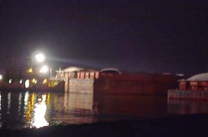
We pulled into the Weber Marine facility after crossing underneath the Sunshine Bridge just as the sun was setting on Tuesday evening. After talking a while with the people who run the facility, we found out that Weber Marine provides support services to the large ocean-going vessels while they are waiting to load or unload their goods. Weber Marine also is involved with the actual loading and unloading of the goods to and from ocean-going vessels. The goods either come from or go to thousands of barges lined up along the shore, which are then staged for transport back up the river. The Weber Marine facility is an around-the-clock operation as the shuffling of barges is a task that goes on without end. Barges are always coming downriver, and more barges are always being sent up river, 24 hours a day, 365 days a year. It's an operation that never sleeps. But we were able to sleep at least a little while that night, tied securely to a barge platform. And all the while the dance of the barges and the buzz of the towboats happened just behind our stern, all night long, as shown in the photo above and left.
|
 The
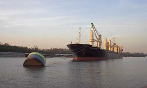
size of the ocean-going vessels is simply enormous. Technically, there are "big" ocean-going vessels and "small" ocean-going vessels, but they all were so much tremendously larger than our boat that in some ways it really didn't manner how big they were. Pictured to the right is a large ocean tanker tied off to a mooring buoy. The mooring buoy alone is many times the size of our vessel in volume! The
size of the ocean-going vessels is simply enormous. Technically, there are "big" ocean-going vessels and "small" ocean-going vessels, but they all were so much tremendously larger than our boat that in some ways it really didn't manner how big they were. Pictured to the right is a large ocean tanker tied off to a mooring buoy. The mooring buoy alone is many times the size of our vessel in volume!
|
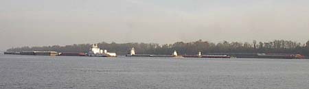 Traffic on the stretch of river between Baton Rouge and New Orleans was by far the most congested we had experienced. The arrays of barges tended to be smaller than some of the ones we had seen higher up on the river, but the frequency of the traffic was greatly increased. The above photo shows a crossing situation with four tows crossing abreast simultaneously. If you'd like to include the BPV Libelula in the above mix, that would be FIVE vessels vying for the same piece of river at the same time. This particular stretch of the lower river was wider than most, and there were no ocean-going vessels unloading their goods, thank goodness! Traffic on the stretch of river between Baton Rouge and New Orleans was by far the most congested we had experienced. The arrays of barges tended to be smaller than some of the ones we had seen higher up on the river, but the frequency of the traffic was greatly increased. The above photo shows a crossing situation with four tows crossing abreast simultaneously. If you'd like to include the BPV Libelula in the above mix, that would be FIVE vessels vying for the same piece of river at the same time. This particular stretch of the lower river was wider than most, and there were no ocean-going vessels unloading their goods, thank goodness!
|
 Pictured
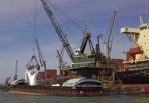
to the right is an ocean-going vessel loading some white stuff into a barge with a crane that will be soon pushed upstream. We speculated that the white stuff could be lime, sugar, or salt (or maybe even something else), but we weren't able to make a positive identification. The ocean tankers we passed came from all over the world, from Russia to Hong Kong and everywhere in between, including a few places of which we had no idea as to where they were located. Sometimes, the letters printed onto the boats to identify them were written in a different alphabet, so it was hard to tell for sure exactly what it was trying to spell. Pictured
to the right is an ocean-going vessel loading some white stuff into a barge with a crane that will be soon pushed upstream. We speculated that the white stuff could be lime, sugar, or salt (or maybe even something else), but we weren't able to make a positive identification. The ocean tankers we passed came from all over the world, from Russia to Hong Kong and everywhere in between, including a few places of which we had no idea as to where they were located. Sometimes, the letters printed onto the boats to identify them were written in a different alphabet, so it was hard to tell for sure exactly what it was trying to spell.
|
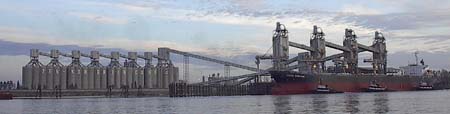 To
the right is a Chinese grain vessel by the name of South Fortune being loaded with grain, awaiting a departure that will most likely take it south through the Panama Canal, and west to China. Note there are three small tugboats holding the vessel against the dock to keep the boat in position for the loading process. To
the right is a Chinese grain vessel by the name of South Fortune being loaded with grain, awaiting a departure that will most likely take it south through the Panama Canal, and west to China. Note there are three small tugboats holding the vessel against the dock to keep the boat in position for the loading process.
|
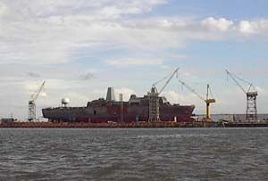 As
we approached the city of New Orleans, we passed by what appeared to be a naval shipyard that was busy building some sort of military vessel. They had three of the exact same vessel under construction, all in different stages of completion. The one vessel was nearly finished, while the vessel pictured to the right was still receiving the plating for its hull and deck structure. As
we approached the city of New Orleans, we passed by what appeared to be a naval shipyard that was busy building some sort of military vessel. They had three of the exact same vessel under construction, all in different stages of completion. The one vessel was nearly finished, while the vessel pictured to the right was still receiving the plating for its hull and deck structure.
|
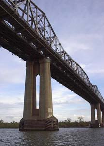 We passed underneath the Huey P. Long Bridge at mile marker 121.5 late Wednesday afternoon. This bridge is significant because it defines where the inland rules of navigation begin, which are different than the international counterparts. All waters downstream of the bridge are governed by the same laws and protocols used for international navigation. The French Quarter in the City of New Orleans is located around mile 95 of the Mississippi River, meaning that the Head of Passes, or mile zero of the Mississippi River, is significantly further downstream than that. The end of the Mississippi River is at good times in the middle of nowhere, and due to the effects of the recent hurricanes, access and resources in that area were even further limited. We had many informed people advise us not to reach the Gulf of Mexico via the end of the Mississippi River, and we heeded their advice. There is more than one waterway that leads to the Gulf, and the path we had chosen would take us through the Industrial Lock at mile 93, which leads to the Industrial Canal, the Intracoastal Waterway, and Lake Pontchartrain. We passed underneath the Huey P. Long Bridge at mile marker 121.5 late Wednesday afternoon. This bridge is significant because it defines where the inland rules of navigation begin, which are different than the international counterparts. All waters downstream of the bridge are governed by the same laws and protocols used for international navigation. The French Quarter in the City of New Orleans is located around mile 95 of the Mississippi River, meaning that the Head of Passes, or mile zero of the Mississippi River, is significantly further downstream than that. The end of the Mississippi River is at good times in the middle of nowhere, and due to the effects of the recent hurricanes, access and resources in that area were even further limited. We had many informed people advise us not to reach the Gulf of Mexico via the end of the Mississippi River, and we heeded their advice. There is more than one waterway that leads to the Gulf, and the path we had chosen would take us through the Industrial Lock at mile 93, which leads to the Industrial Canal, the Intracoastal Waterway, and Lake Pontchartrain.
|
 Upon entering the official Port of New Orleans we were greeted by a large, colorful container ship waiting to be unloaded. Interestingly enough, in this lower part of the river the current had slacked off quite a bit compared to what it had been just a hundred miles upstream. This is due in part to the fact that the river is well over 100 feet deep (and at some places MUCH deeper) in the stretch between Baton Rouge and New Orleans, as compared to otherwise normal river depths of 25-40 feet in the channel upriver. In addition to the slack current, we had been experiencing significant winds on our last day on the Mississippi River that helped to slow our progress. Upon entering the official Port of New Orleans we were greeted by a large, colorful container ship waiting to be unloaded. Interestingly enough, in this lower part of the river the current had slacked off quite a bit compared to what it had been just a hundred miles upstream. This is due in part to the fact that the river is well over 100 feet deep (and at some places MUCH deeper) in the stretch between Baton Rouge and New Orleans, as compared to otherwise normal river depths of 25-40 feet in the channel upriver. In addition to the slack current, we had been experiencing significant winds on our last day on the Mississippi River that helped to slow our progress.
|
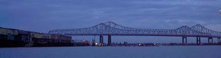 In
spite of the setting sun, falling darkness, and an approaching storm coming up quickly from behind us, we pushed onward towards the downtown area which is just beyond the last bridges to cross the span of the great river, named the 'Crescent City Connection' (shown above). Damage from the recent hurricanes was evident in some places, but not overwhelming from the river perspective. We passed by the French Quarter, and went about two miles further downstream to the entrance of the Industrial Lock at mile 93, where we made a sharp left out of the river's main channel. After 32 days on our nation's mightiest river, we turned our stern upon it and bade it farewell. However, our river journey to the sea was not yet quite complete, and the conclusion of the voyage beckoned us to the salty water and the Gulf of Mexico. In
spite of the setting sun, falling darkness, and an approaching storm coming up quickly from behind us, we pushed onward towards the downtown area which is just beyond the last bridges to cross the span of the great river, named the 'Crescent City Connection' (shown above). Damage from the recent hurricanes was evident in some places, but not overwhelming from the river perspective. We passed by the French Quarter, and went about two miles further downstream to the entrance of the Industrial Lock at mile 93, where we made a sharp left out of the river's main channel. After 32 days on our nation's mightiest river, we turned our stern upon it and bade it farewell. However, our river journey to the sea was not yet quite complete, and the conclusion of the voyage beckoned us to the salty water and the Gulf of Mexico.
|
| |
|
Read More About Next Week >>> |
|