|
|
Week #15 Part II, 15-17.December, 2005
|
New Orleans, LA to New Orleans, LA: Destination Gulf of Mexico |
| |
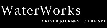
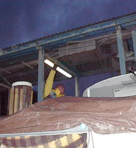
 Our passage through the lock and our ultimate post-river fate came with assistance from a shrimping boat by the name of Capn' Jim. By the time we arrived at the Industrial Lock on Wednesday night it was completely dark, and we were getting low on fuel due in part to the wind we had been fighting all day to get off of the river before darkness fell. Prior to our arrival at the lock, we had identified and verified an open gas station in the hurricane ravaged city of New Orleans less than one mile away from the Industrial Lock. Unfortunately, the lockmasters at the lock were not sympathetic to our cause and forbade us to go to shore to get more fuel. Given the darkness, the waning status of our fuel, the plentiful amount of commercial traffic, and a storm that was beginning to brew, we elected to make friends with Capn' Jim who offered to give us a tow once we got through the lock. He was headed into the bayou where he informed us it would be safe. So we passed him a line and went on one of the wildest rides of our lives through the darkness left in the wake of the hurricanes. Near the end of our tow in the early hours of the morning, we came across a harbor containing silhouettes of boats that had been tossed about like tinker toys, partially illuminated by a bright moon. In the morning we awoke to a new light and found ourselves in Bayou Bienvenue in the Parish of St. Bernard, as pictured above right. Our passage through the lock and our ultimate post-river fate came with assistance from a shrimping boat by the name of Capn' Jim. By the time we arrived at the Industrial Lock on Wednesday night it was completely dark, and we were getting low on fuel due in part to the wind we had been fighting all day to get off of the river before darkness fell. Prior to our arrival at the lock, we had identified and verified an open gas station in the hurricane ravaged city of New Orleans less than one mile away from the Industrial Lock. Unfortunately, the lockmasters at the lock were not sympathetic to our cause and forbade us to go to shore to get more fuel. Given the darkness, the waning status of our fuel, the plentiful amount of commercial traffic, and a storm that was beginning to brew, we elected to make friends with Capn' Jim who offered to give us a tow once we got through the lock. He was headed into the bayou where he informed us it would be safe. So we passed him a line and went on one of the wildest rides of our lives through the darkness left in the wake of the hurricanes. Near the end of our tow in the early hours of the morning, we came across a harbor containing silhouettes of boats that had been tossed about like tinker toys, partially illuminated by a bright moon. In the morning we awoke to a new light and found ourselves in Bayou Bienvenue in the Parish of St. Bernard, as pictured above right.
|
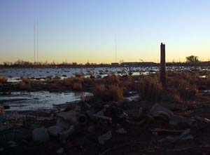
 Indeed, many of the sights we witnessed dimly the night before became more distinguishable during the light of day. Here the effects of Hurricane Katrina and Rita were unmistakable. One of the many boats that had been tossed to shore or partially sunken during the storms is shown in the photo to the left. This sizable shrimping vessel with a hefty fiberglass hull was effortlessly lifted up and slammed down on top of a large garbage dumpster, which is now embedded in the boat's bow. This boat is definitely trashed, along with many others in the bayou. A few vessels weathered the storm with minimal damage, but this seemed to be the exception rather than the rule in this area. Indeed, many of the sights we witnessed dimly the night before became more distinguishable during the light of day. Here the effects of Hurricane Katrina and Rita were unmistakable. One of the many boats that had been tossed to shore or partially sunken during the storms is shown in the photo to the left. This sizable shrimping vessel with a hefty fiberglass hull was effortlessly lifted up and slammed down on top of a large garbage dumpster, which is now embedded in the boat's bow. This boat is definitely trashed, along with many others in the bayou. A few vessels weathered the storm with minimal damage, but this seemed to be the exception rather than the rule in this area.
|
 We
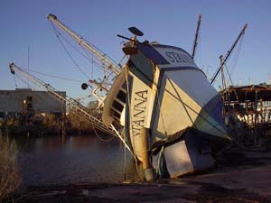
ventured onto land in part to have a look around but also to seek out some fuel so that we could safely finish the journey. The Parish of St. Bernard was one of the hardest hit areas by the storms. We met a local who took us around and showed us some of the devastation firsthand. Many houses in the area were submerged in over 12 feet of water which left behind a solid 2 feet of mud. Some of the houses were starting to be rebuilt; others had yet to be touched. No businesses in that area were open, save for a gas station about 3 miles away which was running its operations out of a cash box on a folding table amongst beverages floating in coolers and snack foods being sold to people working to begin the rebuilding process. We arrived in St. Bernard Parish on Thursday, December 15, 2005, about two weeks shy of the 4-month anniversary of the storm. It is humbling to think what had transpired in the months before our arrival; all the mud and debris that had to be cleared just to get the roads open, the disposal of everything damaged by the touch of water, the immense loss of life and property. Our explorations gave us a more realistic sense of the magnitude of damage that the storms caused, the power that water can unleash in its fury. There was, however, hope present too. Our friend who guided us through the devastation had recently been provided a FEMA trailer, and had a pile of Drywall sitting in his house waiting to be installed. A sign outside of an auto repair shop was spray-painted onto a piece of 4'x8' plywood, "Will Open Soon". We
ventured onto land in part to have a look around but also to seek out some fuel so that we could safely finish the journey. The Parish of St. Bernard was one of the hardest hit areas by the storms. We met a local who took us around and showed us some of the devastation firsthand. Many houses in the area were submerged in over 12 feet of water which left behind a solid 2 feet of mud. Some of the houses were starting to be rebuilt; others had yet to be touched. No businesses in that area were open, save for a gas station about 3 miles away which was running its operations out of a cash box on a folding table amongst beverages floating in coolers and snack foods being sold to people working to begin the rebuilding process. We arrived in St. Bernard Parish on Thursday, December 15, 2005, about two weeks shy of the 4-month anniversary of the storm. It is humbling to think what had transpired in the months before our arrival; all the mud and debris that had to be cleared just to get the roads open, the disposal of everything damaged by the touch of water, the immense loss of life and property. Our explorations gave us a more realistic sense of the magnitude of damage that the storms caused, the power that water can unleash in its fury. There was, however, hope present too. Our friend who guided us through the devastation had recently been provided a FEMA trailer, and had a pile of Drywall sitting in his house waiting to be installed. A sign outside of an auto repair shop was spray-painted onto a piece of 4'x8' plywood, "Will Open Soon".
|
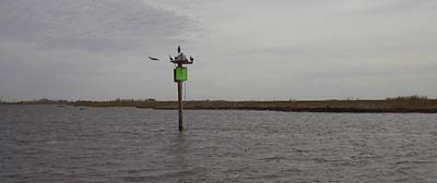 Our
departure from the Bayou Bienvenue left us humbled by a firsthand perspective of extreme devastation, and also left us with a full tank of gas. In spite of all that had happened in New Orleans and the surrounding areas, we still had a journey to complete and the Gulf of Mexico beckoned. From the Bayou, we momentarily jumped back into the Industrial Canal in order to make our way into the Intracoastal Waterway. The Intracoastal Waterway took us to the destination where we had determined our journey would officially end. A green daymarker labeled with the number "7" designated the channel that would lead us out of the Intracoastal Waterway and into the Gulf of Mexico. Our
departure from the Bayou Bienvenue left us humbled by a firsthand perspective of extreme devastation, and also left us with a full tank of gas. In spite of all that had happened in New Orleans and the surrounding areas, we still had a journey to complete and the Gulf of Mexico beckoned. From the Bayou, we momentarily jumped back into the Industrial Canal in order to make our way into the Intracoastal Waterway. The Intracoastal Waterway took us to the destination where we had determined our journey would officially end. A green daymarker labeled with the number "7" designated the channel that would lead us out of the Intracoastal Waterway and into the Gulf of Mexico.
|
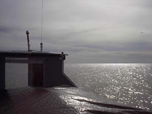 102 days after the launch of the BPV Libelula into Chautauqua Lake in western New York State, we proudly pedaled our vessel to the conclusion of the journey at a place called Lake Borgne, where the Gulf of Mexico begins, around 11 am on Friday 16.December, 2005. Tracing a total distance by water of over 2,100 miles, we followed a path on which everyone's water travels without pause. Some of that water that joined us in the entry to the Gulf we had seen before, all of that water we will see again at one point or another. As we entered the Gulf on this calm day, we paused and reflected on the accomplishment of our travels, took a few photos, noted our GPS position as 89 49.272' W x 30 02.435' N, and then turned the boat around and headed for home. 102 days after the launch of the BPV Libelula into Chautauqua Lake in western New York State, we proudly pedaled our vessel to the conclusion of the journey at a place called Lake Borgne, where the Gulf of Mexico begins, around 11 am on Friday 16.December, 2005. Tracing a total distance by water of over 2,100 miles, we followed a path on which everyone's water travels without pause. Some of that water that joined us in the entry to the Gulf we had seen before, all of that water we will see again at one point or another. As we entered the Gulf on this calm day, we paused and reflected on the accomplishment of our travels, took a few photos, noted our GPS position as 89 49.272' W x 30 02.435' N, and then turned the boat around and headed for home.
|
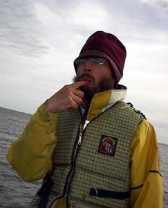 Quickly, though, before we made it too far on the homeward stretch we needed to thwart any skeptics who didn't believe that Lake Borgne was really part of the Gulf of Mexico. In order to do this, Morgan dipped his finger into the water and sucked on it for a bit to affirm that the water had indeed become salty, thus proving beyond a doubt that we had reached our destination. In all reality, the body of water called Lake Borgne is more of a harbor than an actual lake. It is surrounded on three sides by small pieces of land, with the fourth side being connected to the Gulf of Mexico proper. You can also check out the data here from the scientific instrument that we were towing, compliments of the YSI Environmental, if you have any further questions as to the nature of the body of water of the journey's conclusion. Quickly, though, before we made it too far on the homeward stretch we needed to thwart any skeptics who didn't believe that Lake Borgne was really part of the Gulf of Mexico. In order to do this, Morgan dipped his finger into the water and sucked on it for a bit to affirm that the water had indeed become salty, thus proving beyond a doubt that we had reached our destination. In all reality, the body of water called Lake Borgne is more of a harbor than an actual lake. It is surrounded on three sides by small pieces of land, with the fourth side being connected to the Gulf of Mexico proper. You can also check out the data here from the scientific instrument that we were towing, compliments of the YSI Environmental, if you have any further questions as to the nature of the body of water of the journey's conclusion.
|
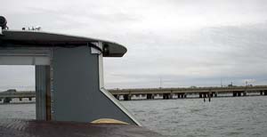 Because we had reached the Gulf of Mexico, we no longer had river currents to worry about, but there were currents of another sort caused by tidal influences. In examining the tide and current predictions, we found it in our best interest to leave the Gulf of Mexico in a different manner than we had arrived. Therefore, we continued on the Intracoastal Waterway for a bit, and then zipped up north into Chef Menteur pass, which brought us out into Lake Pontchartrain. We had planned to do this segment of the journey in fair weather because both Lake Pontchartrain and the edge of the Gulf of Mexico can create large waves much more intense than those found on the river. Pontoon boats are not built to handle such waves, and our window of opportunity to cross Pontchartrain was narrowing as winds began to pickup in the late afternoon. Due to the forecast for increasing winds and the always-ominous threat of the setting sun, we chose to cross Pontchartrain in the quickest manner possible in order to get to our New Orleans destination safely. Instead of crossing under Interstate 10 and some railroad bridges in the middle of the lake where a high span had been built in order to accommodate vessels of height, we chose the shorter route and opted to hug the shore and try to cross under the low part of the road structure. It was kind of a gutsy move, as we did not know what the clearance was underneath the road structure, and the tide was also on the rise. As can be seen from the photo above, it certainly doesn't look like there is an abundance of overhead clearance, and it turns out there wasn't! We ended up crossing under about five structures, each with decreasing amounts of overhead clearance. The good news is that we managed to make it underneath all of them, though the last one was low enough to take our navigation lights as a sacrifice. Having literally scraped by underneath the last bridge, we had a relatively straight shot to reach the City of New Orleans. Because we had reached the Gulf of Mexico, we no longer had river currents to worry about, but there were currents of another sort caused by tidal influences. In examining the tide and current predictions, we found it in our best interest to leave the Gulf of Mexico in a different manner than we had arrived. Therefore, we continued on the Intracoastal Waterway for a bit, and then zipped up north into Chef Menteur pass, which brought us out into Lake Pontchartrain. We had planned to do this segment of the journey in fair weather because both Lake Pontchartrain and the edge of the Gulf of Mexico can create large waves much more intense than those found on the river. Pontoon boats are not built to handle such waves, and our window of opportunity to cross Pontchartrain was narrowing as winds began to pickup in the late afternoon. Due to the forecast for increasing winds and the always-ominous threat of the setting sun, we chose to cross Pontchartrain in the quickest manner possible in order to get to our New Orleans destination safely. Instead of crossing under Interstate 10 and some railroad bridges in the middle of the lake where a high span had been built in order to accommodate vessels of height, we chose the shorter route and opted to hug the shore and try to cross under the low part of the road structure. It was kind of a gutsy move, as we did not know what the clearance was underneath the road structure, and the tide was also on the rise. As can be seen from the photo above, it certainly doesn't look like there is an abundance of overhead clearance, and it turns out there wasn't! We ended up crossing under about five structures, each with decreasing amounts of overhead clearance. The good news is that we managed to make it underneath all of them, though the last one was low enough to take our navigation lights as a sacrifice. Having literally scraped by underneath the last bridge, we had a relatively straight shot to reach the City of New Orleans.
|
 And reach the City of New Orleans we did! We made it into the Orleans Marina a little before sunset, just as the wind really began to pick up. Our little gamble and sacrificial navigation lights paid off in great dividends, for we had entered into a safe harbor. The Orleans Marina is well protected from Lake Pontchartrain, and therefore suffered minimal damage during the hurricanes. The adjacent marina, which is less protected, did not fair nearly as well; many of the boats kept there ended up being destroyed as a result of the storm. We had a celebratory dinner that evening in honor of the conclusion of our journey consisting of some flavorful macaroni and cheese, baked potatoes, and corn, complimented by a bit of red wine from New York that we had carried onboard throughout the journey. And reach the City of New Orleans we did! We made it into the Orleans Marina a little before sunset, just as the wind really began to pick up. Our little gamble and sacrificial navigation lights paid off in great dividends, for we had entered into a safe harbor. The Orleans Marina is well protected from Lake Pontchartrain, and therefore suffered minimal damage during the hurricanes. The adjacent marina, which is less protected, did not fair nearly as well; many of the boats kept there ended up being destroyed as a result of the storm. We had a celebratory dinner that evening in honor of the conclusion of our journey consisting of some flavorful macaroni and cheese, baked potatoes, and corn, complimented by a bit of red wine from New York that we had carried onboard throughout the journey.
|
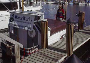 The
next day, Saturday, we hung out our banner for all to see from our slip in Orleans Marina, and prepared the boat to be hauled out of the water for the journey home. Captured here are some of the BPV Libelula's final moments afloat before she is pulled from the water for the last time. The
next day, Saturday, we hung out our banner for all to see from our slip in Orleans Marina, and prepared the boat to be hauled out of the water for the journey home. Captured here are some of the BPV Libelula's final moments afloat before she is pulled from the water for the last time.
|
| |
|
Read More About Next Week >>> |
|