|
|
Week #14, 04-10.December, 2005
|
Greenville, MS to Angola, LA: Mississippi River Mile 537 to Mile 305 |
| |
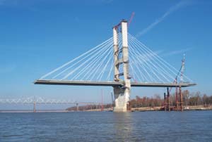 Immediately downstream of Greenville, MS we came across the new Greenville Bridge, currently under construction (you can see the "old Greenville Bridge" still being used in the background). The manner in which these bridges are constructed is quite complicated. First, towers are constructed with foundations set deep into the riverbed. Once the tower is complete, the road surface begins to be built outwards from the vertical structure. With each additional piece of roadbed attached, a white support cable is strung from the tower to the road. Eventually, the road and cables from one tower meet the road and cables from another tower, or make their way to solid ground, and the bridge is complete! It is quite interesting to see such a large structure being assembled in midair, balanced in a seemingly precarious fashion! Immediately downstream of Greenville, MS we came across the new Greenville Bridge, currently under construction (you can see the "old Greenville Bridge" still being used in the background). The manner in which these bridges are constructed is quite complicated. First, towers are constructed with foundations set deep into the riverbed. Once the tower is complete, the road surface begins to be built outwards from the vertical structure. With each additional piece of roadbed attached, a white support cable is strung from the tower to the road. Eventually, the road and cables from one tower meet the road and cables from another tower, or make their way to solid ground, and the bridge is complete! It is quite interesting to see such a large structure being assembled in midair, balanced in a seemingly precarious fashion!
|
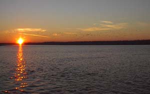 On Monday evening we found a good spot to spend the night on the river at mile 471 near Arcadia Point and just upstream of the Cottonwood Sandbar. We headed out of the main channel and tucked up behind a dike, where lots of sand was beginning to settle out. We arrived just as the sun was about to drop below the horizon, and came across a large flock of what seemed to be American Pelicans. The birds took to flight as we entered their environment, and can be seen as small dark specs in the sky in the photo to the above left. On Monday evening we found a good spot to spend the night on the river at mile 471 near Arcadia Point and just upstream of the Cottonwood Sandbar. We headed out of the main channel and tucked up behind a dike, where lots of sand was beginning to settle out. We arrived just as the sun was about to drop below the horizon, and came across a large flock of what seemed to be American Pelicans. The birds took to flight as we entered their environment, and can be seen as small dark specs in the sky in the photo to the above left.
|
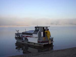 Our stopping point for the night turned out to be one of the most serene places we spent on the entire river. We were far enough away from the main channel to barely even notice the towboats and their barges that continued traveling up and down the river all night long. We awoke in the morning to dense fog on the water, but clear skies overhead. The fog lifted in the area immediately surrounding us quite quickly, however, it lingered in a dense bank over the main channel for a number of hours as seen in the background of the photo to the right. We had made it a policy not to travel in the fog, because it is difficult to see where you are going, making it likely that either you'll hit something, or even more likely, that something will hit you. Our stopping point for the night turned out to be one of the most serene places we spent on the entire river. We were far enough away from the main channel to barely even notice the towboats and their barges that continued traveling up and down the river all night long. We awoke in the morning to dense fog on the water, but clear skies overhead. The fog lifted in the area immediately surrounding us quite quickly, however, it lingered in a dense bank over the main channel for a number of hours as seen in the background of the photo to the right. We had made it a policy not to travel in the fog, because it is difficult to see where you are going, making it likely that either you'll hit something, or even more likely, that something will hit you.
|
 While
waiting for the fog to lift, Morgan took the opportunity to scrape some ice off of the window that had accumulated during the night. Due to the combination of the fog and the overnight temperatures, which had dropped down into the twenties, a fine layer of white frost covered everything on the boat, including the tarp, as can be seen in the photo to the left. We were really quite lucky as far as the temperature was concerned, because we experienced a very mild autumn with relatively warm temperatures until the middle of November. But the cold air had to set in at some point, and even though we were headed in a southerly direction, we experienced our fair share of cold weather. The coldest it ever got outside was about 22 degrees Fahrenheit, and many nights were spent in the low thirties. It was always about 6-10 degrees warmer inside the boat than it was outside, but we had no heat source on the vessel and therefore had to resort to warm clothes and sleeping bags to keep us from freezing. While
waiting for the fog to lift, Morgan took the opportunity to scrape some ice off of the window that had accumulated during the night. Due to the combination of the fog and the overnight temperatures, which had dropped down into the twenties, a fine layer of white frost covered everything on the boat, including the tarp, as can be seen in the photo to the left. We were really quite lucky as far as the temperature was concerned, because we experienced a very mild autumn with relatively warm temperatures until the middle of November. But the cold air had to set in at some point, and even though we were headed in a southerly direction, we experienced our fair share of cold weather. The coldest it ever got outside was about 22 degrees Fahrenheit, and many nights were spent in the low thirties. It was always about 6-10 degrees warmer inside the boat than it was outside, but we had no heat source on the vessel and therefore had to resort to warm clothes and sleeping bags to keep us from freezing.
|
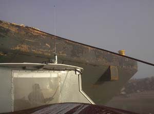 As we continued to wait for the fog to lift, we decided to go over and check out a barge that was moored in the same off-channel nook as us. There weren't any people working on this barge and it seemed as if it was put there as a place for on-river storage. Sometimes in pictures and even when seen on the river, it is easy to forget just how large a single barge really is. This barge was mostly empty, and its raked bow can be seen in the photo to the right towering overtop of the BPV Libelula. If we had ever encountered a barge in this fashion out in midstream we would have been crushed in an instant. And keep in mind this is a photo of just a single barge. Many of the towboats on the river are pushing over 40 of these barges lashed together to form an impressively large vessel! As we continued to wait for the fog to lift, we decided to go over and check out a barge that was moored in the same off-channel nook as us. There weren't any people working on this barge and it seemed as if it was put there as a place for on-river storage. Sometimes in pictures and even when seen on the river, it is easy to forget just how large a single barge really is. This barge was mostly empty, and its raked bow can be seen in the photo to the right towering overtop of the BPV Libelula. If we had ever encountered a barge in this fashion out in midstream we would have been crushed in an instant. And keep in mind this is a photo of just a single barge. Many of the towboats on the river are pushing over 40 of these barges lashed together to form an impressively large vessel!
|
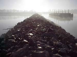 The fog had not yet lifted, so we pulled our vessel up to a sandy spot and set the spud in order to do a bit more exploring. We walked out on one of the stone dikes that were constructed by the Army Corps of Engineers to direct the flow of the Lower Mississippi River. There are no locks or dams on this part of the river like there were on the Ohio, so the entire river is free flowing. Therefore, a different kind of system was designed to control where the water goes. The dikes are constructed like fingers that stick out from the shore to channel the flow of water into the center of the channel. This also in effect carves out the bottom of the channel, making it deep enough for commercial vessels to safely pass. There are thousands of these stone dikes along the entire length of the river, an elegant, simple system of engineering that harnesses the power of nature for the advantage of civilization. At the end of the dike, we were fortunate enough to have a brief visit from what appeared to be a river otter as it played among the eddies that spin off the end of the structure. The fog had not yet lifted, so we pulled our vessel up to a sandy spot and set the spud in order to do a bit more exploring. We walked out on one of the stone dikes that were constructed by the Army Corps of Engineers to direct the flow of the Lower Mississippi River. There are no locks or dams on this part of the river like there were on the Ohio, so the entire river is free flowing. Therefore, a different kind of system was designed to control where the water goes. The dikes are constructed like fingers that stick out from the shore to channel the flow of water into the center of the channel. This also in effect carves out the bottom of the channel, making it deep enough for commercial vessels to safely pass. There are thousands of these stone dikes along the entire length of the river, an elegant, simple system of engineering that harnesses the power of nature for the advantage of civilization. At the end of the dike, we were fortunate enough to have a brief visit from what appeared to be a river otter as it played among the eddies that spin off the end of the structure.
|
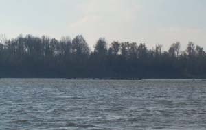 The level of the lower river is constantly rising and falling with the change of the seasons and the amount of precipitation that falls across 40 percent of the landmass of the United States. The stone dike in the above picture is quite defined and seems like it would be hard to miss. But this is not always the case! Pictured to the right is another example of a stone dike, of which you can just barely make out a couple of rocks breaking the surface of the water. This is of special concern for smaller vessels that might not always want to stay in the main navigation channel. Oftentimes dikes can be hidden and submerged underwater when the river level rises, and sometimes they'll only be underwater a couple of inches. This means that if you're traveling downstream at 5 mph in a boat that draws about one foot of water and you pass over an underwater dike that is 6 inches below the surface, it is quite likely that you'll tear a big hole in the bottom of your boat as it scrapes over sharp rocks, and promptly sink to the bottom. There are often buoys that mark the ends of dikes in order to help identify their locations, but it nevertheless requires constant vigilance to avoid unintentionally stumbling across such a navigational hazard. The level of the lower river is constantly rising and falling with the change of the seasons and the amount of precipitation that falls across 40 percent of the landmass of the United States. The stone dike in the above picture is quite defined and seems like it would be hard to miss. But this is not always the case! Pictured to the right is another example of a stone dike, of which you can just barely make out a couple of rocks breaking the surface of the water. This is of special concern for smaller vessels that might not always want to stay in the main navigation channel. Oftentimes dikes can be hidden and submerged underwater when the river level rises, and sometimes they'll only be underwater a couple of inches. This means that if you're traveling downstream at 5 mph in a boat that draws about one foot of water and you pass over an underwater dike that is 6 inches below the surface, it is quite likely that you'll tear a big hole in the bottom of your boat as it scrapes over sharp rocks, and promptly sink to the bottom. There are often buoys that mark the ends of dikes in order to help identify their locations, but it nevertheless requires constant vigilance to avoid unintentionally stumbling across such a navigational hazard.
|
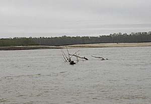 Speaking of navigational hazards, we also always had to keep our eyes open for floating debris, sometimes called snags or sawyers. Especially as the river level would rise, logs, twigs and fallen trees would be swept from the banks and into the stream. The barges' constant motion in the center of the main channel would usually keep that area relatively clear of this flotsam and jetsam, however much was to be found along the edges and in other out-of-the-way places. Noted author Mark Twain named his good friend Tom after this phenomenon that can be seen pictured above left. Speaking of navigational hazards, we also always had to keep our eyes open for floating debris, sometimes called snags or sawyers. Especially as the river level would rise, logs, twigs and fallen trees would be swept from the banks and into the stream. The barges' constant motion in the center of the main channel would usually keep that area relatively clear of this flotsam and jetsam, however much was to be found along the edges and in other out-of-the-way places. Noted author Mark Twain named his good friend Tom after this phenomenon that can be seen pictured above left.
|
 One
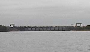
of the more fascinating structures on the Mississippi River is located near mile 314 on the lower river and is called the Old River Control structure, part of which is pictured to the right. Rivers are constantly changing their course, jumping their banks to find a faster, easier, way to the sea. The river is in this sense alive, not carved in stoned, but rather carved in sand and mud which is much more amorphous. In the middle part of the 20th century, people began to realize that the river was trying to change its course yet again, and in a major way. The Atchafalaya River is a major distributary of the Mississippi River, and it was noticed that more and more water was flowing out of the Mississippi River and into the Atchafalaya ever year. This process, left unchecked, would have eventually resulted in all of the water from the Mississippi River flowing into a new river, leaving the existing lower 300 miles of the lower Mississippi to turn into a large, calm bayou. This would have isolated the City of New Orleans and one of the world's largest shipping ports from its river artery into the center of the United States. People weren't too keen on the idea of shifting all of the infrastructure of the existing shipping port a couple hundred miles west to the mouth of the Atchafalaya, so they decided instead to build a big wall to prevent the Mississippi River from flowing its path of choice. That's essentially what the Old River Control structure is all about, telling the Old Man River where to flow. It should be interesting to see how long he'll listen! John McPhee talks about this extensively in his book The Control of Nature, a good read if you are interested in finding out more. One
of the more fascinating structures on the Mississippi River is located near mile 314 on the lower river and is called the Old River Control structure, part of which is pictured to the right. Rivers are constantly changing their course, jumping their banks to find a faster, easier, way to the sea. The river is in this sense alive, not carved in stoned, but rather carved in sand and mud which is much more amorphous. In the middle part of the 20th century, people began to realize that the river was trying to change its course yet again, and in a major way. The Atchafalaya River is a major distributary of the Mississippi River, and it was noticed that more and more water was flowing out of the Mississippi River and into the Atchafalaya ever year. This process, left unchecked, would have eventually resulted in all of the water from the Mississippi River flowing into a new river, leaving the existing lower 300 miles of the lower Mississippi to turn into a large, calm bayou. This would have isolated the City of New Orleans and one of the world's largest shipping ports from its river artery into the center of the United States. People weren't too keen on the idea of shifting all of the infrastructure of the existing shipping port a couple hundred miles west to the mouth of the Atchafalaya, so they decided instead to build a big wall to prevent the Mississippi River from flowing its path of choice. That's essentially what the Old River Control structure is all about, telling the Old Man River where to flow. It should be interesting to see how long he'll listen! John McPhee talks about this extensively in his book The Control of Nature, a good read if you are interested in finding out more.
We should also note that this week we visited the two lovely and historic towns of Vicksburg and Natchez in Mississippi, and found ourselves on Saturday night a bit south of the Old Control Structure near mile 305. Here we spent the night in a safe side channel full of sand between Shreves Bar and the famous Louisiana State Penal Farm. Just upriver of this point, we'd entered the state of Louisiana proper, as its borders now flanked both sides of the river. |
| |
|
Read More About Next Week >>> |
|