|
|
Week #6, 09-15.October, 2005
|
Parkersburg, WV to Portsmouth, OH: Ohio River Mile 187 to Mile 363 |
| |
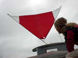 With no school to visit until Thursday, we had ample time this week to get to know the Ohio River. There were many miles to be covered, but a lot of time to do so. We had hoped to bike for much of the time, but the weather had other plans. Lucky for us, the rain from the previous week had abated, but the steel grey skies and wind remained. Though for much of the time it blew downstream, which we thought would have given us a nice push along the water, the wind proved to be a bit of problem. Perhaps a lighter breeze would have worked in our favor, but a steady wind of about 15mph prevailed and we found it difficult to keep the boat facing downstream. The design of the Libelula is such that the back half of the boat has a much bigger surface area and thus serves like a kind of sail for the wind to blow against. When this happens, the boat gets turned upstream, facing into the wind. This particular phenomenom is known as the vessel having 'weather helm.' Despite our efforts using the tiller and paddle wheels to keep her pointed down wind, nothing seemed to work. We even spent several hours trying out different ways and places for rigging up the sail near the bow of the boat with hopes that it would balance out the sail effect on the stern. Here, Aimee gazes up hopefully at the sail, placed for the moment where it was originally intended on the roof of the galley. Finally, at the end of day two, we pulled up on the public docks near Parkersburg, WV, and Morgan did some quick work on the bikes to give us more steering power. He redesigned the drivetrain of the bicycles so that they could be pedaled both backwards as well as forwards, thus adding a reverse gear to the paddlewheel. This new addition has so far seemed to work quite well. When we feel the wind beginning to turn the boat, one of us can pedal forwards and the other backwards, which allows for twice the turning power. With no school to visit until Thursday, we had ample time this week to get to know the Ohio River. There were many miles to be covered, but a lot of time to do so. We had hoped to bike for much of the time, but the weather had other plans. Lucky for us, the rain from the previous week had abated, but the steel grey skies and wind remained. Though for much of the time it blew downstream, which we thought would have given us a nice push along the water, the wind proved to be a bit of problem. Perhaps a lighter breeze would have worked in our favor, but a steady wind of about 15mph prevailed and we found it difficult to keep the boat facing downstream. The design of the Libelula is such that the back half of the boat has a much bigger surface area and thus serves like a kind of sail for the wind to blow against. When this happens, the boat gets turned upstream, facing into the wind. This particular phenomenom is known as the vessel having 'weather helm.' Despite our efforts using the tiller and paddle wheels to keep her pointed down wind, nothing seemed to work. We even spent several hours trying out different ways and places for rigging up the sail near the bow of the boat with hopes that it would balance out the sail effect on the stern. Here, Aimee gazes up hopefully at the sail, placed for the moment where it was originally intended on the roof of the galley. Finally, at the end of day two, we pulled up on the public docks near Parkersburg, WV, and Morgan did some quick work on the bikes to give us more steering power. He redesigned the drivetrain of the bicycles so that they could be pedaled both backwards as well as forwards, thus adding a reverse gear to the paddlewheel. This new addition has so far seemed to work quite well. When we feel the wind beginning to turn the boat, one of us can pedal forwards and the other backwards, which allows for twice the turning power.
|
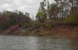 We have had a nice glance into the past all along the Ohio River. The charts we are using are a special edition commemorating the bicentennial of the famous 1803-1806 journey of Lewis and Clark. There is a special symbol on the chart whenever we pass a spot that is significant to the trip that Lewis took down the Ohio in 1803 on his way to meeting up with Clark in Louisville, KY. Generally, it is a place along the riverbank that Lewis mentioned in his journals, perhaps because he and his crew over-nighted in the area, were able to do some hunting, or found the natural features significant. This photo was taken off Buffington Island, Ohio around mile 217 (meaning we were about 217 miles from Pittsburgh) and the notes in our charts explain that "On September 16, 1803, Lewis recorded in his journal, 'thermometer this morning in the air 54 [degrees] in the water 72 [degrees] a thick fog which continued so thick that we did not set out until 8oClock in the morning.' He noted in his journal that he shot some squirrels while his men got the boats through the rifles at Buffington Island. They went to the north end, navigating by hugging the right bank going down the river." Also significant in this photo is the house slipping down the bank of the island. Bank erosion is a constant problem on a riverbank, made evident by this uninhabited barn poised to fall right into the drink. We have had a nice glance into the past all along the Ohio River. The charts we are using are a special edition commemorating the bicentennial of the famous 1803-1806 journey of Lewis and Clark. There is a special symbol on the chart whenever we pass a spot that is significant to the trip that Lewis took down the Ohio in 1803 on his way to meeting up with Clark in Louisville, KY. Generally, it is a place along the riverbank that Lewis mentioned in his journals, perhaps because he and his crew over-nighted in the area, were able to do some hunting, or found the natural features significant. This photo was taken off Buffington Island, Ohio around mile 217 (meaning we were about 217 miles from Pittsburgh) and the notes in our charts explain that "On September 16, 1803, Lewis recorded in his journal, 'thermometer this morning in the air 54 [degrees] in the water 72 [degrees] a thick fog which continued so thick that we did not set out until 8oClock in the morning.' He noted in his journal that he shot some squirrels while his men got the boats through the rifles at Buffington Island. They went to the north end, navigating by hugging the right bank going down the river." Also significant in this photo is the house slipping down the bank of the island. Bank erosion is a constant problem on a riverbank, made evident by this uninhabited barn poised to fall right into the drink.
|
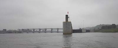 One of the locks we went through early on in the week was no ordinary dam; the lockmaster informed us that it also produced electricity. We asked him how they decided how much water to let flow through the dam he explained that he wasn't sure, because it was controlled by an electric company all the way over in Roanoke, VA! As we left the lock we got a better look at Racine dam and speculated that the walls between the legs of the bridge in this photo are what control the flow of the water and produce hydroelectricity, One of the locks we went through early on in the week was no ordinary dam; the lockmaster informed us that it also produced electricity. We asked him how they decided how much water to let flow through the dam he explained that he wasn't sure, because it was controlled by an electric company all the way over in Roanoke, VA! As we left the lock we got a better look at Racine dam and speculated that the walls between the legs of the bridge in this photo are what control the flow of the water and produce hydroelectricity,
|
 Late Wednesday evening we arrived at Huntington, WV, one of the larger towns we have stopped at along the river. We found a nice spot to stay for the night just downriver of some old barges and got out to do some exploring. It was a curious sight; the chart showed a large city along the river's edge, but to look at it, only the bridges and a few tall buildings gave away the city's presence. Everywhere else, it was green and wild looking. A closer inspection gave up the reason: we had come across our first levee, a large, thick wall built close to the river's edge in an attempt to protect the city when the river floods. In Huntington, the levee is set back about 50 feet from the river and nothing but trees and plants lie in between. You can get a sense of how big the levee is with Morgan standing on the top with his bass fiddle. Late Wednesday evening we arrived at Huntington, WV, one of the larger towns we have stopped at along the river. We found a nice spot to stay for the night just downriver of some old barges and got out to do some exploring. It was a curious sight; the chart showed a large city along the river's edge, but to look at it, only the bridges and a few tall buildings gave away the city's presence. Everywhere else, it was green and wild looking. A closer inspection gave up the reason: we had come across our first levee, a large, thick wall built close to the river's edge in an attempt to protect the city when the river floods. In Huntington, the levee is set back about 50 feet from the river and nothing but trees and plants lie in between. You can get a sense of how big the levee is with Morgan standing on the top with his bass fiddle.
|
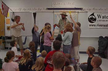 The next morning we made our way up the levee and walked along the top straight to Central City Elementary School where we did programs for three fourth grade classrooms. In this photo, the students are assembling a small version of the Mississippi River watershed. Our seven volunteers are each given a "watershed": a funnel--representing a water catchment area--with a hose--representing a river--attached to it. We put down a bucket for the Gulf of Mexico and have the student with the largest watershed direct his or her hose (the Mississippi River) into the Gulf. The other six students are then free to reconstruct the branching pattern of the rivers that flow into the Mississippi. When all is assembled, we add a little bit of water to each watershed and observe how all the water eventually ends up in the Gulf of Mexico. Then we add a bit of pollution (really red food coloring) into the top of a watershed and demonstrate how it affects everything downstream. Somehow, nobody ends up covered in food coloring or wet. Usually! The next morning we made our way up the levee and walked along the top straight to Central City Elementary School where we did programs for three fourth grade classrooms. In this photo, the students are assembling a small version of the Mississippi River watershed. Our seven volunteers are each given a "watershed": a funnel--representing a water catchment area--with a hose--representing a river--attached to it. We put down a bucket for the Gulf of Mexico and have the student with the largest watershed direct his or her hose (the Mississippi River) into the Gulf. The other six students are then free to reconstruct the branching pattern of the rivers that flow into the Mississippi. When all is assembled, we add a little bit of water to each watershed and observe how all the water eventually ends up in the Gulf of Mexico. Then we add a bit of pollution (really red food coloring) into the top of a watershed and demonstrate how it affects everything downstream. Somehow, nobody ends up covered in food coloring or wet. Usually!
|
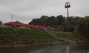 When we left Huntington the next day, we came across this "McDonald's Dock," as it is labeled on our charts, a little before noon on the Ohio side of the river. As near as we can tell, the dock was put in by McDonald's in order to encourage boaters to stop by for a bite to eat. Not to be outdone, the chart showed a "Pizza Hut Dock" just upriver which had apparently been removed for the season or possibly was run off the river due to ferocious competition between the two restaurants. We took advantage of the dock and the restrooms, but nothing on the menu was very appealing, so we kept on going. The first and only time we have seen such a phenomenon! When we left Huntington the next day, we came across this "McDonald's Dock," as it is labeled on our charts, a little before noon on the Ohio side of the river. As near as we can tell, the dock was put in by McDonald's in order to encourage boaters to stop by for a bite to eat. Not to be outdone, the chart showed a "Pizza Hut Dock" just upriver which had apparently been removed for the season or possibly was run off the river due to ferocious competition between the two restaurants. We took advantage of the dock and the restrooms, but nothing on the menu was very appealing, so we kept on going. The first and only time we have seen such a phenomenon!
|
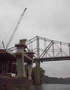 Later in the afternoon, we passed a milestone in our journey that might have gone unnoticed without the aid of a sign along the river--we had reached Middleport, Ohio, the mid-way point between Pittsburgh and Cincinnati. Just down river of the sign, we passed a bridge that was under construction. In the photo, the old bridge in the background is partially hidden by one of the legs of the new bridge that is being built out from the right descending bank. Another milestone we hit that day was making it to Kentucky. At mile 317 we left West Virginia behind and Kentucky became the state we looked to on our left. The border of the two states ran along the Big Sandy River, a tributary of the Ohio and a river with much barge activity as a lot of coal production takes place along its shores. The towns along this stretch of the river give a hint as to the reason for all the activity: "Ashland, KY;" "Coal Grove, OH;" "Ironton, OH." Later in the afternoon, we passed a milestone in our journey that might have gone unnoticed without the aid of a sign along the river--we had reached Middleport, Ohio, the mid-way point between Pittsburgh and Cincinnati. Just down river of the sign, we passed a bridge that was under construction. In the photo, the old bridge in the background is partially hidden by one of the legs of the new bridge that is being built out from the right descending bank. Another milestone we hit that day was making it to Kentucky. At mile 317 we left West Virginia behind and Kentucky became the state we looked to on our left. The border of the two states ran along the Big Sandy River, a tributary of the Ohio and a river with much barge activity as a lot of coal production takes place along its shores. The towns along this stretch of the river give a hint as to the reason for all the activity: "Ashland, KY;" "Coal Grove, OH;" "Ironton, OH."
|
| 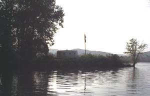 The kind folks at Holiday Point Marina offered up a berth for the night so that we would be able to use their amenities including electricity and the showers. The marina is one of the largest we have seen along the Ohio, and it had plenty of character. Randy, the gentleman who greeted us upon our arrival, told us about the homemade draw bridge that connects the two sides of the marina together (only one person can walk across at a time) and gave us the story of the "spaceship" that marks the entrance. The ship, pictured here to the right, was actually a bet that a man made with his friends many years ago. He thought that he could make a boat out of concrete. They thought not. He built the boat--its launch brought out the national news media--and it docked at Holiday Point for many years before it came to permanently rest at the peninsula near the entrance to the marina's cove. Someone put lights on it so that at night it glows just like a spaceship! The kind folks at Holiday Point Marina offered up a berth for the night so that we would be able to use their amenities including electricity and the showers. The marina is one of the largest we have seen along the Ohio, and it had plenty of character. Randy, the gentleman who greeted us upon our arrival, told us about the homemade draw bridge that connects the two sides of the marina together (only one person can walk across at a time) and gave us the story of the "spaceship" that marks the entrance. The ship, pictured here to the right, was actually a bet that a man made with his friends many years ago. He thought that he could make a boat out of concrete. They thought not. He built the boat--its launch brought out the national news media--and it docked at Holiday Point for many years before it came to permanently rest at the peninsula near the entrance to the marina's cove. Someone put lights on it so that at night it glows just like a spaceship!
|
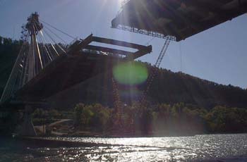 Our second unfinished bridge of the week showed up two days later between Fullerton, Kentucky and Portsmouth, Ohio. Unlike the bridge near Middleport, this one was almost done and we could see that it was one of the new style suspension bridges that have dotted the Ohio River. All that was left to complete was this middle section pictured here and another small piece near the Ohio side. We had a good amount of time to examine the bridge because a strong head wind prevented us from moving very quickly. In fact, it was all we could do to keep from being pushed backwards. Finally, we gave up pedaling and started the motor. When we rounded the next bend in the river and found that the wind was still strong we decided to try something new: motoring in idle while pedaling. The combined propulsion worked quite well and with a bit of experimenting we found that pedaling gave us an additional half to full mile push. It was nice to find another option for traveling that allowed us to bridge ( ahem ) the gap between motoring and biking. Our second unfinished bridge of the week showed up two days later between Fullerton, Kentucky and Portsmouth, Ohio. Unlike the bridge near Middleport, this one was almost done and we could see that it was one of the new style suspension bridges that have dotted the Ohio River. All that was left to complete was this middle section pictured here and another small piece near the Ohio side. We had a good amount of time to examine the bridge because a strong head wind prevented us from moving very quickly. In fact, it was all we could do to keep from being pushed backwards. Finally, we gave up pedaling and started the motor. When we rounded the next bend in the river and found that the wind was still strong we decided to try something new: motoring in idle while pedaling. The combined propulsion worked quite well and with a bit of experimenting we found that pedaling gave us an additional half to full mile push. It was nice to find another option for traveling that allowed us to bridge ( ahem ) the gap between motoring and biking.
|
| |
|
Read More About Next Week >>> |
|