|
|
Week #11, 13-19.November, 2005
|
Cairo, IL to Caruthersville, MS: Mississippi River Mile 955 to Mile 840 |
| |
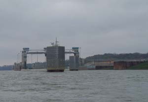
 Sunday morning marked a momentous occasion on our journey--we were to pass through our last lock on the Ohio River and one of the last locks of the entire journey. The Lower Mississippi River is free-flowing and therefore has no locks or dams. Consequently, it was a bittersweet moment when we learned that the lock was actually closed! We were excited to go through our last lock, especially because this lock was one of only two old locks left on the river today--referred to as Old Lock 53, its design is more archaic than the other, newer locks we had passed through. Old Locks 52 and 53 on the Ohio River were built in the 1920's and have been in use ever since! However, the reason the lock was closed caught our attention: the river level was high enough that the water was the same height on both sides of the dam. Part of the dam had been removed to allow vessels to safely pass over the top of the dam. It was a strange sensation to pass directly through (and over!) a dam instead of going through the lock as we floated on by, as is pictured above and to the right. Sunday morning marked a momentous occasion on our journey--we were to pass through our last lock on the Ohio River and one of the last locks of the entire journey. The Lower Mississippi River is free-flowing and therefore has no locks or dams. Consequently, it was a bittersweet moment when we learned that the lock was actually closed! We were excited to go through our last lock, especially because this lock was one of only two old locks left on the river today--referred to as Old Lock 53, its design is more archaic than the other, newer locks we had passed through. Old Locks 52 and 53 on the Ohio River were built in the 1920's and have been in use ever since! However, the reason the lock was closed caught our attention: the river level was high enough that the water was the same height on both sides of the dam. Part of the dam had been removed to allow vessels to safely pass over the top of the dam. It was a strange sensation to pass directly through (and over!) a dam instead of going through the lock as we floated on by, as is pictured above and to the right.
|
 Just down river we were greeted by another peculiar sight. The Army Corps Of Engineers is working on building a new lock to replace the last two old locks on the Ohio (Locks 52 & 53), and we passed by the work site where the new lock is being built. It looked as though they were well on their way to finishing the lock, but the work on the dam had not yet begun. A lockmaster up river had told us that the project may not be finished for another eleven years, and funding for the project may be in jeopardy. The picture to the left speaks to the enormity of such a task as to harness the control of a river, the great mass of moving water. Just down river we were greeted by another peculiar sight. The Army Corps Of Engineers is working on building a new lock to replace the last two old locks on the Ohio (Locks 52 & 53), and we passed by the work site where the new lock is being built. It looked as though they were well on their way to finishing the lock, but the work on the dam had not yet begun. A lockmaster up river had told us that the project may not be finished for another eleven years, and funding for the project may be in jeopardy. The picture to the left speaks to the enormity of such a task as to harness the control of a river, the great mass of moving water.
|
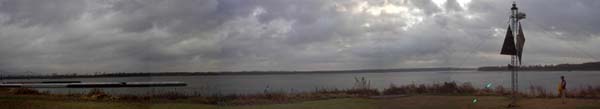
On Sunday afternoon we arrived at Cairo, IL (if you want to sound like a local, you'll pronounce it "Care-oh"), another big port for barge traffic and the point of land at the tippy bottom of Illinois that is hugged by the Mississippi at its northwest side and by the Ohio at the southeast. The land literally comes to a point where you can stand at the end and watch the Ohio and Mississippi flow together. The picture here was taken at the point looking downriver. To the left is the Ohio and to the right is the Mississippi. Aimee stands to the right of the photo as well, near the mile marker for the end of the Ohio River.
|
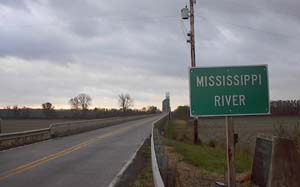 We had a tough time settling on a place to stay for the night because both sides of the Ohio River are full of barge traffic, and there were no public docks to which to tie the boat. It looked as if we might have to look for a spot on the Mississippi, and before we knew it, we were heading upstream along a new river. We finally settled on a spot right under the Missouri/Illinois Bridge that leads into Cairo over the Mississippi: it was still relatively close to town, it protected us from the wake of barge traffic, and was in the current lee of an island so we wouldn't have to worry too much about being swept downriver. In the picture to the right, the two-lane bridge heads off to Missouri, and a sign alerts travelers to the fact that they are traversing the Mississippi River. Not 50 yards away, another bridge leads from Illinois to Kentucky, and a similar sign makes note of the Ohio River. We had a tough time settling on a place to stay for the night because both sides of the Ohio River are full of barge traffic, and there were no public docks to which to tie the boat. It looked as if we might have to look for a spot on the Mississippi, and before we knew it, we were heading upstream along a new river. We finally settled on a spot right under the Missouri/Illinois Bridge that leads into Cairo over the Mississippi: it was still relatively close to town, it protected us from the wake of barge traffic, and was in the current lee of an island so we wouldn't have to worry too much about being swept downriver. In the picture to the right, the two-lane bridge heads off to Missouri, and a sign alerts travelers to the fact that they are traversing the Mississippi River. Not 50 yards away, another bridge leads from Illinois to Kentucky, and a similar sign makes note of the Ohio River.
|
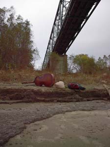 After walking over four miles round trip to visit the fourth graders at Bennett Elementary School on Monday with our program props laid out on the shore in the photo to the left, our plan was to start out down the Mississippi the next morning. The weather, however, had other ideas. We awoke Tuesday to a nasty looking sky and strong winds; the weather on the radio called for high winds and rain throughout the day. Disappointed, we decided that that was not a good way to start our first day on the Mississippi and we settled in to ride out the storm on shore. As it turns out, we made the right decision--several tornados passed within a few miles of us, bringing visibility of less than 25 feet and winds gusting to 60 mph. It rained in short down powers all day long, at one point turning to hail. That night, the radio warned that due to the heavy rains, the river was predicted to rise almost eight feet in Cairo. We had already noticed that the river was rising, and brought the boat as close to shore as we could before going to sleep, setting the alarm for three hours later. After walking over four miles round trip to visit the fourth graders at Bennett Elementary School on Monday with our program props laid out on the shore in the photo to the left, our plan was to start out down the Mississippi the next morning. The weather, however, had other ideas. We awoke Tuesday to a nasty looking sky and strong winds; the weather on the radio called for high winds and rain throughout the day. Disappointed, we decided that that was not a good way to start our first day on the Mississippi and we settled in to ride out the storm on shore. As it turns out, we made the right decision--several tornados passed within a few miles of us, bringing visibility of less than 25 feet and winds gusting to 60 mph. It rained in short down powers all day long, at one point turning to hail. That night, the radio warned that due to the heavy rains, the river was predicted to rise almost eight feet in Cairo. We had already noticed that the river was rising, and brought the boat as close to shore as we could before going to sleep, setting the alarm for three hours later.
|
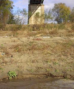 When we awoke in the middle of the night, we found that the shore was fast disappearing, and again pulled the spud and moved the boat closer to shore. We had to repeat the procedure two more times in the middle of the night in order to keep the boat from floating away down the Mississippi. The light of day showed that the river had risen about five feet during the night, enough to cover much of the shore we had been walking along the past few days. The picture to the right shows where the water stood when we departed on Wednesday morning. This is in stark contrast to the above photo which shows the shoreline as it looked when we arrived at Cairo on Sunday--the ledge where the bass and backpack rest in the above photo is nearly crested by water in the photo to the right! When we awoke in the middle of the night, we found that the shore was fast disappearing, and again pulled the spud and moved the boat closer to shore. We had to repeat the procedure two more times in the middle of the night in order to keep the boat from floating away down the Mississippi. The light of day showed that the river had risen about five feet during the night, enough to cover much of the shore we had been walking along the past few days. The picture to the right shows where the water stood when we departed on Wednesday morning. This is in stark contrast to the above photo which shows the shoreline as it looked when we arrived at Cairo on Sunday--the ledge where the bass and backpack rest in the above photo is nearly crested by water in the photo to the right!
|
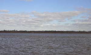 After weathering the previous day's storm, we were ready to set out on the Mississippi. At the confluence we looked for the legendary mixing of the two rivers--the clearer green of the Ohio next to the muddy waters of the Mississippi. For several hundred yards after the point of confluence the waters continue on their separate paths, where a distinct line marking the boundaries of the two rivers is visible in this photo. After weathering the previous day's storm, we were ready to set out on the Mississippi. At the confluence we looked for the legendary mixing of the two rivers--the clearer green of the Ohio next to the muddy waters of the Mississippi. For several hundred yards after the point of confluence the waters continue on their separate paths, where a distinct line marking the boundaries of the two rivers is visible in this photo.
|
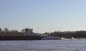 One of the most important things we have to learn to contend with along the Mississippi is the increased size and speed of the barge traffic. In particular, we had to be concerned with the wake produced by up-bound tows. The strong current they have to fight to make way up river requires them to use a great deal of engine power, creating powerfully large waves in their wake. The trick is to avoid getting stuck between a barge and the outside of one of the many bends in the river. To do so would mean there would be little room between our boat, the wake, and the river bank, creating a tumultuous area that we would not want to be in the middle of. Waves created as an upstream tow navigates the outside of a bend can be anywhere from 6-10 feet depending on the horsepower of the vessel and the amount of current it is pushing against. The barge array in this picture was one of the biggest we had seen--nearly 5 barges wide by 7 long--leaving a tall, ugly looking wake behind as it headed up river. Tows on the Ohio River are constrained by the size of the navigation locks, and were never larger than 3 barges wide by 5 long. We've been told that the record for the largest array of barges ever pushed on the Mississippi contained 72 units and was 8 barges wide by 9 long! One of the most important things we have to learn to contend with along the Mississippi is the increased size and speed of the barge traffic. In particular, we had to be concerned with the wake produced by up-bound tows. The strong current they have to fight to make way up river requires them to use a great deal of engine power, creating powerfully large waves in their wake. The trick is to avoid getting stuck between a barge and the outside of one of the many bends in the river. To do so would mean there would be little room between our boat, the wake, and the river bank, creating a tumultuous area that we would not want to be in the middle of. Waves created as an upstream tow navigates the outside of a bend can be anywhere from 6-10 feet depending on the horsepower of the vessel and the amount of current it is pushing against. The barge array in this picture was one of the biggest we had seen--nearly 5 barges wide by 7 long--leaving a tall, ugly looking wake behind as it headed up river. Tows on the Ohio River are constrained by the size of the navigation locks, and were never larger than 3 barges wide by 5 long. We've been told that the record for the largest array of barges ever pushed on the Mississippi contained 72 units and was 8 barges wide by 9 long!
|
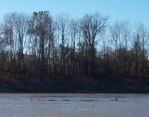 The next day we spotted the Loch Ness monster off the starboard side of our boat. At first, we thought it might just be some floating tree limbs, but a closer look and our powerful zoom lense showed that it was indeed Nessie herself as the photo to the left proves without a doubt. We figure that she must have been on vacation from her usual haunts in Scotland, and what better place to visit than the mighty Mississippi? It makes a lot of sense if you sit down and think about it for a moment. After three days of strong winds, sharp bends, and huge barges, we were ready for anything, and the sighting only whetted our appetite for more adventure along the Mississippi. The next day we spotted the Loch Ness monster off the starboard side of our boat. At first, we thought it might just be some floating tree limbs, but a closer look and our powerful zoom lense showed that it was indeed Nessie herself as the photo to the left proves without a doubt. We figure that she must have been on vacation from her usual haunts in Scotland, and what better place to visit than the mighty Mississippi? It makes a lot of sense if you sit down and think about it for a moment. After three days of strong winds, sharp bends, and huge barges, we were ready for anything, and the sighting only whetted our appetite for more adventure along the Mississippi.
|
| |
|
Read More About Next Week >>> |
|